


Mapping national livestock routes in Ethiopia
In a collaborative effort to enhance pastoral livelihoods and regional economic stability, the Supporting Pastoralism and Agriculture in Recurrent and Protracted Crises (SPARC) program is partnering with the Intergovernmental Authority on Development (IGAD) Centre for Pastoral Areas and Livestock Development (ICPALD) and the governments of Ethiopia and Kenya to create national maps of livestock routes in the two countries, the first time this is being done in both nations. The partnership is a contribution to the implementation of the IGAD Transhumance Protocol.
Pastoralism relies on livestock mobility for animals to access seasonal grazing areas, water sources, and access markets. This mobility is increasingly threatened by land use changes, encroachments, and inadequate policy frameworks. Blocked or fragmented livestock corridors reduce pastoralists' ability to cope with drought, intensify resource conflicts, and lead to land degradation.
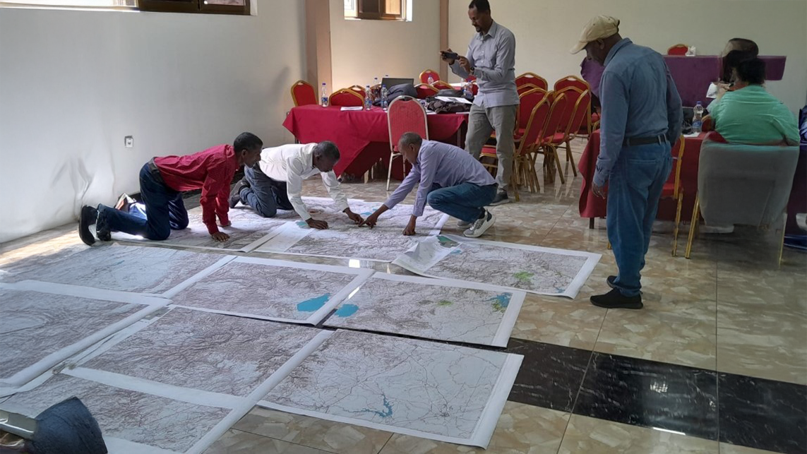
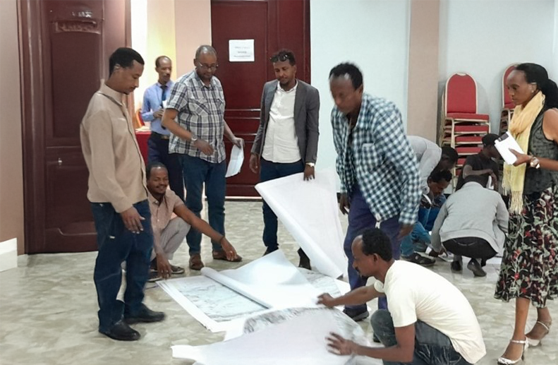
The initiative to map livestock routes in Kenya and Ethiopia opened with a workshop where government experts from across livestock-producing areas of Ethiopia, SPARC researchers and members of ICPALD began an initial mapping of primary routes. The meeting, held on 26-28 February 2025 in Adama, Ethiopia, marks the first comprehensive attempt to document the exact locations and status of livestock routes and supporting services across the country.
The IGAD region: A livestock powerhouse
The IGAD region — Djibouti, Eritrea, Ethiopia, Kenya, Somalia, South Sudan, Sudan and Uganda — is a livestock powerhouse. It is home to 43% of Africa’s cattle (160 million), 34% of its sheep and goats (308 million), and nearly half the world’s camels (19 million), totaling 488 million animals (FAO 2021). These resources, managed largely by pastoralists in arid lands, underpin food security and economies — contributing up to 70% of agricultural gross domestic product in some countries — while exports, primarily to the Middle East, generate vital income. Despite climate challenges, livestock remain central to livelihoods and nutrition in the region.
The livestock route mapping process will produce detailed, national-level maps that include data on the functionality of livestock routes, the distribution of water points, veterinary posts, markets, and grazing and resting areas used by pastoralists. Once finalized, policymakers will be able to use digital versions of the maps to inform national information systems to make decisions about protecting routes and providing services along them. This includes land use and development planning, for natural resource management, and for service delivery for livestock and people.
'The mapping process is expected to yield several outputs, including detailed maps of major livestock routes in Ethiopia and Kenya, data for IGAD and national ministries, and case studies on mobility challenges,' explained Fiona Flintan, the International Livestock Research Institute (ILRI) senior scientist and rangelands governance specialist leading the initiative.
Properly mapped routes will help governments and stakeholders design strategies and plans to facilitate transhumance and reduce conflicts between pastoralists and other land users. Well-maintained corridors improve the condition of livestock upon arrival at markets, increasing economic returns for pastoralists and boosting the livestock sector’s contribution to national economies. As IGAD works towards formalizing cross-border trade and transhumance agreements, updated maps will provide critical data to align policy and infrastructure planning.
National support for the initiative
At the Ethiopia workshop Girma Mulugeta, the advisor of state minister for agriculture in Ethiopia, highlighted Ethiopia’s rich livestock potential while acknowledging existing challenges.
He said Ethiopia has reasonably good livestock resources with potential for scale, biodiversity, and water resources. However, the country faces many challenges, such as land-use changes, restricted access to grazing lands, and inadequate infrastructure along livestock routes.
'To improve the situation, comprehensive mapping of livestock route and documentation are necessary for resource planning, while investments in infrastructure, including water, feed, and veterinary services, will enhance productivity and reduce resource related conflicts while contributing to food security and economic resilience in the region.' — Girma Mulugeta
The Ethiopia meeting successfully identified key livestock routes, markets, and associated infrastructure. Participants acknowledged the importance of mobility in sustaining pastoralist livelihoods and emphasized the need for improved policy frameworks, investments in livestock infrastructure, and enhanced cross-border collaboration.
The digital maps generated following the workshop will serve as indispensable tools for strategic planning and decision-making. They will also be vital resources for national information systems, informing decisions related to land use, natural resource management, and service delivery for both livestock and pastoral communities.
The national workshop in Ethiopia brought together 41 participants, representing cross-sectoral government ministries and departments from all regions specializing in animal health, livestock production, geographic information systems, rangeland management, livestock production and animal science, agricultural economics and rural development.
The process of developing the livestock route maps
- It began with the acquisition of baseline topographic maps on which livestock routes were drawn.
- Regional mapping teams then mapped out the route locations, water points, and grazing areas.
- The maps and data collected are digitized and will be presented back to the participants in a second meeting for any adjustments and validation.
- Once reviewed, the maps will be finalized and digitized before being provided to the government.
- These digital tools will be integrated into national livestock data systems, providing policymakers with a centralized platform for monitoring and managing livestock movements, improving regional planning, and supporting pastoralist livelihoods.
On 27-29 May 2025, ILRI will convene an initial Kenya livestock route mapping workshop in Nairobi with government stakeholders and members of ICPALD.
Resources
- Transhumance protocol
- IGAD Strategy for Sustainable and Resilient Livestock Development in View of Climate Change (2022–37)
Acknowledgement
This article was first published on the SPARC website


.")


")
")