


")
Drones prove their worth in measuring livestock methane in Africa
In May 2024, ILRI and partners shared news of the first drone flights over rangeland animals in Africa to test whether this technology could help measure livestock methane. Now, the results are in, and they show that drones deliver accurate, reliable methane measurements.
Ruminant livestock such as cattle, sheep, goats, and camels produce methane as part of their digestion process. When microbes in their stomachs break down feed, they also produce methane, which is a potent greenhouse gas that contributes to global warming.
Understanding and measuring methane emissions accurately is essential for designing effective mitigation strategies. Thus the researchers tested if a drone equipped with a methane sensor could detect and quantify the concentration of methane from grazing animals, offering a practical new tool for researchers.
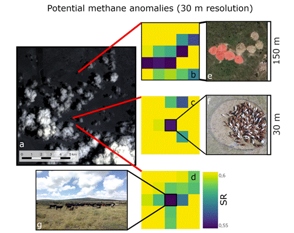
For countries in Africa, it can deliver better livestock emissions data to strengthen national greenhouse gas inventories and help test new ways to reduce methane. The drone was tested by scientists from the University of Oslo, the Norwegian Institute of Bioeconomy Research (NIBIO), the University of Milan, and the International Livestock Research Institute’s (ILRI) Mazingira Centre at ILRI’s Kapiti Research Station in Kenya. They used the drone to measure the methane of herds of cattle, sheep, goats and camels—also the first time camel emissions have been measured in Africa. Their findings, now published in Biogeosciences, confirm that:
- By combining prior knowledge with new drone measurements, the researchers calculated methane emissions that were similar to those derived from the Intergovernmental Panel on Climate Change (IPCC) Tier 1 and Tier 2 methods used for national greenhouse gas inventories.
- The drone could detect increases in methane emissions after animals grazed, showing it can capture changes in emissions throughout the day.
- The drone successfully detected methane emissions from herds of around 100 cattle, 170 sheep, 140 goats, and 40 camels, demonstrating that the approach works under practical, real-world conditions.
- Satellite data can identify areas with livestock activities that could induce higher atmospheric methane , guiding where and when drones should fly for more detailed measurements.
“Drones are changing how we measure livestock emissions,” said Claudia Arndt, senior scientist and team leader of ILRI’s Mazingira Centre.
“For the first time, we can accurately measure methane from animals in their natural grazing environments, using a non-invasive and location- flexible method. This opens the door to improving national greenhouse gas inventories, and measuring impact of mitigation strategies for climate-smart livestock systems that work for African farmers.”
The next stage of research will focus on expanding this approach and securing funding to acquire a dedicated research drone at ILRI. The methane sensor used in this study was provided by partners in Norway, and the drone itself was rented for the field campaign, an arrangement that proved effective but costly. Establishing in-house drone capability at Mazingira Centre would make this technology more accessible and affordable for ongoing research across Africa.
With a dedicated system, Mazingira Centre and its partners could conduct regular methane monitoring in different livestock systems and environments, linking drone data with satellite and ground-based measurements to build comprehensive methane maps for African livestock, as well as test the effectiveness of mitigation strategies.
Through this approach, Africa will be able to generate its own high-quality data—strengthening national reporting, improving emission estimates, and ensuring that local production systems are accurately represented in global climate assessments. This could open opportunities for climate finance and policy engagement.
Read the full paper here.
Acknowledgements
The study was led by Alouette van Hove, PhD researcher at the University of Oslo, who conducted the drone-based fieldwork in Kenya together with John Hulth, technician of University of Oslo. Van Hove is supervised by associate professor Norbert Pirk University of Oslo, a pioneer in drone-based atmospheric measurements. Rodolfo Ceriani, PhD student at University of Milan participated to the field campaign and carried out the satellite data analysis, under supervision of associate professor Francesco Fava (University of Milan). Vincent Odongo, postdoctoral researcher at the Mazingira Centre, supported the field campaign and provided wind data from the eddy covariance tower at ILRI’s Kapiti Research Station.
The work was carried out under the CircAgric Project, led by Vibeke Lind (principal investigator, NIBIO), a livestock emissions measurement specialist who provided overall project leadership and scientific guidance. Claudia Arndt (team leader, Mazingira Centre, ILRI) contributed conceptual input and expertise on livestock greenhouse gas emissions and emission calculations based on national inventory methodologies.
Financial support
This research has been supported by the Research Council of Norway (projects #333232 CircAgric-GHG and #301552 Spot-On) and the European Research Council (project #101116083 ACTIVATE). It also contributes to the strategic research initiative LATICE (#UiO/GEO103920), the Center for Biogeochemistry in the Anthropocene, and the Center for Computational and Data Science at the University of Oslo.
The study was further supported by the CGIAR Initiatives Livestock and Climate and Mitigate+: Low-Emission Food Systems, funded by contributors to the CGIAR Trust Fund, as well as the EU-DeSIRA ESSA project (Earth observation and environmental sensing for climate-smart sustainable agropastoralism ecosystem transformation in East Africa).


")


